Projects: TwelveTrees | OneRiver
OneRiver projects normally involve following and photographing a river from its source to the sea. I have something different in mind. Leicestershire has one outstanding geographical feature, the river that bisects it into two distinct halves - sticky but fertile Jurassic Lias to the east, Triassic marls, the Precambrian island of Charnwood Forest and coalfields to the west. And the River Soar runs neatly along a deep bed of boulder clay and modern alluvium in the fold between the two, as it has done since the glaciers retreated.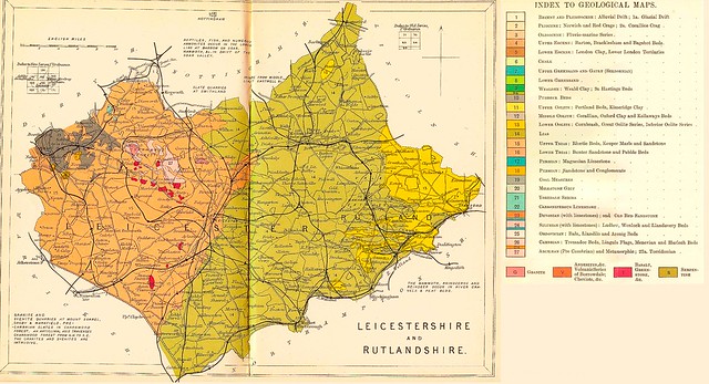
In its 55 mile course through Leicestershire the Soar falls only 100 metres in elevation, so don't expect towering waterfalls or grand rapids. I may be able to manage the odd weir where the river squanders a whole two metres in one go.
What is this OneRiver Project?
A portfolio of 12 photographs documenting the course of the River Soar through the county of Leicestershire.
How long will it take?
Until I have 12 images of acceptable quality. This is a geographical project not a chronological one.
What's the poetry about?
That's the jeopardy. If it works, the fragments will build into an impression of the river alongside the pictures. I have no idea if the final version will hang together.
 |  |  |
 |  | |
 |
 |  |  |
 |  |  |
 |  |
Projects: TwelveTrees | OneRiver